
Class 1 Hydrographic Surveys
Sea Surveyor conducts hydrographic surveys using single-beam and multibeam depth sounders with hull-mounted transducers. We use the most stringent Class 1 standards required by the U.S. Army Corps of Engineers for pre- and post-dredge hydrographic surveys. Sea Surveyor’s hydrographic surveys are typically used for:
- Nautical Charting
- Multibeam Sonar Surveys
- Class 1 Pre-Dredge Surveys
- Lake and Reservoir Surveys
- River Navigability Surveys
- Beach Transects and Profiles
- Emergency Assessment Surveys
- Marine Vegetation Mapping
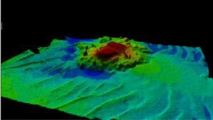
3-D Multibeam Sounding Chart
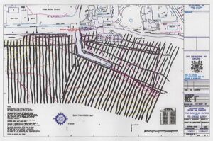
Pre-Dredge Hydrographic Contour Chart
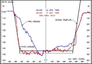
pre and post dredging channel cross sections